Float from Africa to Asia from Antarctica to the Americas. Explore major lakes and mountain regions from a satellite view. See the world in a new way!
1.
In small groups, explore the seven continents on Earth. Find satellite views of each continent. Locate major lakes and mountain ranges, coastal regions, and boundaries. Gather information about other major features on each continent, such as peninsulas, glaciers, deserts, and rain forests.
2.
Continents are usually presented on globes and maps. How might your group display the continents and their major features in a new way? Try a mobile! Here’s one way to make one.
3.
Outline the shape of each landmass using Crayola Erasable Colored Pencils on patterned paper, making continents to scale. Include details such as inlets, bays, peninsulas, and capes along the coastlines. Mark major lakes, mountain ranges, and other major features.
4.
Use Crayola Scissors to carefully cut around the outline of each continent. Choose the two or three most prominent major features, such as lakes and mountain ranges. Cut small pieces of contrasting-colored paper to place behind your cut-outs. Use a Crayola Glue Stick to attach the papers. If you wish, add another layer of continent-shaped paper on the back to reinforce your continents.
5.
To make a mobile base, cut patterned paper to fit around a cardboard tube. Add a title to your mobile. You might choose CONTINENTS or THE WORLD. Or cut out free-form letters for your title. Attach contrasting paper on the back side of the cut-out words to
6.
Wrap the title around the cardboard tube and glue. Use varying lengths of ribbon, yarn, or string to attach to each continent to the mobile base. Arrange the continents so they hang at different lengths. You’re ready to display your mobile!
Explore the rich visual culture of ancient Egypt! Create a captivating multimedia portrait in historic Egyptian style.
A famous section of Beijing, the capital of China, is surrounded by a moat. Imagine being in The Forbidden City, where a
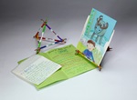
Explore Prince Edward Island with Anne of Green Gables! Draw and describe this enchanting Canadian island in an accordio
How do pets or wildlife care for their young? Discover how young animals change as they grow!
What pets do you feed, walk, or groom? Izak, who lives in Lapland, takes care of a reindeer! Match animals with owners a
Does animal brain size match body size? Affect intelligence? Sculpt the brains of three vertebrates to compare and contr
Students go wild filling Beasty Books and their brains with fun facts and figures about their favorite creatures.
Looking for a pizzazzy book report format? Try bas-relief sculpture to add a new dimension to your next presentation!